Water Quality and Water Quantity Monitoring on the Upper Yellowstone River for RiverNET

YERC field technicians collect data on the Upper Yellowstone River in support of our RiverNET program.
YERC began its RiverNET program with water quality and quantity monitoring on the Upper Yellowstone River in Paradise Valley, Montana. Water quality monitoring consists of the collection and in-house analysis of grab samples from 26 sites located between Gardiner and Livingston. Nine of these sites are located along the mainstem of Yellowstone River at locations that provided consistent spatial distribution, were accessible, and are within the proximity of the mouths of important tributaries. The remaining 17 sites are located on or at the mouths of tributaries. Tributary site locations were selected and prioritized with the help of Pat Byorth of Trout Unlimited. Factors contributing to the selection of tributary sites include, but are not limited to; high volume flow areas, trout spawning habitat, irrigation sources, and areas modified by land use. Water quality samples are collected on a bi-weekly basis during three seasonal intervals. These include the “pre-growing season” from mid-May to mid-June, the “growing season” from early-July to late- September, and “post-growing season” in mid-November. Once collected, YERC analyzes water quality samples at our field station located in Paradise Valley. We test our samples for multiple parameters including temperature, pH, nitrate, nitrate, total nitrogen, orthophosphate, and total phosphorus. These parameters are important indicators of watershed health and provide insight into potential impairments affecting the river. Our data collected during water quality sampling is uploaded to the online RiverNET application where it can be viewed by anyone who has created a free account.

YERC field technicians manually measure the discharge on a tributary to the Yellowstone River.
RiverNET in Paradise Valley is supported by a network of local donors who contribute through our Adopt-A-River Program. This program allows supporters to “adopt” their favorite section of the river and help protect it by funding water quality or water quantity monitoring on that stretch of river. Click here to learn more about Adopt-A-River on the Upper Yellowstone and our wonderful donors! We are very grateful for everyone who has helped to make RiverNET possible.
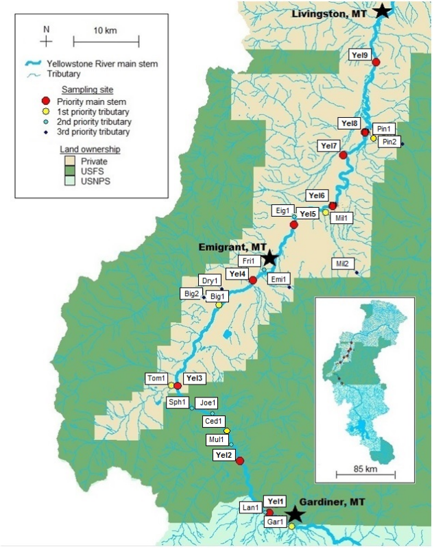
Locations of YERC water quality sampling sites along the Upper Yellowstone River and its tributaries.
YERC’s water quantity monitoring on the Upper Yellowstone consists of the collection of stage (depth), discharge (flow), and temperature measurements at 15 sites in Paradise Valley. These measurements are collected both manually and by in-situ sensors. YERC field technicians manually measure stage by reading the depth of streams at established gauging stations. Additionally, we can manually determine discharge by wading streams and measuring the flow. We then use our manual measurements to create “rating curves.” These are graphs which show the empirical relationship between stage and discharge. Additionally, stage and temperature measurements are taken by bluetooth-enabled Onset MX2001 sensors. These sensors are installed and maintained by YERC field technicians, but are able to continuously collect and store data on their own. The stage measurements from these sensors can then be used to estimate stream discharge with our rating curves. YERC technicians and volunteers can upload the data from these Onset sensors to our online RiverNET application simply by pairing their cell phones to the sensors via bluetooth and syncing the data with the app. Water quantity data is essential for many users in Paradise Valley including irrigators, white-water rafters, and fly fishermen. Additionally, it can be used in combination with our water quality data to determine nutrient loads on the river and its tributaries.